Morocco Map
0
0
As an Amazon Associate and affiliate partner, Menrva Books earns from qualifying purchases. Learn more
Author Description
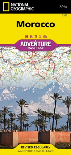
• Waterproof • Tear-Resistant • Travel Map National Geographic's Morocco Adventure Map provides global travelers with the perfect combination of detail and perspective, highlighting hundreds of points of interest and the unique and exotic destinations within the country. This expertly crafted map includes the locations of thousands of cities and towns with an index for easily locating them, plus a clearly marked road network complete with distances and designations for motorways, dual carriageways, major roadways, scenic routes, and more. In addition to typical sites of interest such as World Heritage sites, national parks, mosques, churches, and archeological sites, this map includes Morocco's many casbahs, and marabouts, making it invaluable to travelers hoping to experience the country's rich history and culture. Beaches, yachting harbors, and areas popular for fishing and surfing dot Morocco's extensive Mediterranean and Atlantic coastlines. Other recreational destinations such as ski resorts, golf courses, spas, caves, and oases are included as well. Morocco's northern half is shown on the front side of the print map and includes the cities of Tangier, Tetouan, Fez, Rabat, Casablanca, and Marrakesh. The reverse side of the map covers the southern portion of the country and includes a large inset map of Western Sahara. The Kingdom of Morocco is a part of the Maghreb region of North Africa that includes Tunisia, Algeria, Mauritania, and Libya with which it shares historical, cultural, and linguistic ties. Primarily a nation of farmers, the country is dominated by the Atlas Mountains that separate the fertile coastal regions from the harsh Sahara. These high, rugged mountains helped protect Morocco from colonization until the early 20th century when the French and Spanish brought their influence to the Islamic region. Every Adventure Map is printed on durable synthetic paper, making them waterproof, tear-resistant and tough — capable of withstandin
Menrva's Summary
THE THESIS
This map serves as a comprehensive guide to the diverse landscapes and cultural heritage of Morocco, designed for travelers seeking detailed information beyond typical tourist routes. National Geographic's expertise in cartography is evident in this Adventure Map, which meticulously details road networks, cities, towns, and thousands of points of interest. It highlights historical sites, natural parks, and unique cultural landmarks such as casbahs and marabouts, providing essential context for understanding Morocco's rich history and culture. The map's dual-sided coverage ensures a complete view of the country, including an inset of Western Sahara, making it an indispensable tool for any visitor.
THE SCOPE MAP
- Detailed road network including motorways, dual carriageways, major roadways, and scenic routes with distance markers.
- Thousands of cities and towns with an index for easy location.
- Numerous points of interest: World Heritage sites, national parks, mosques, churches, archeological sites, casbahs, and marabouts.
- Recreational destinations: beaches, yachting harbors, fishing and surfing areas, ski resorts, golf courses, spas, caves, and oases.
- Coverage of Morocco's northern half on the front and southern portion with Western Sahara inset on the reverse.
- Information on Morocco's geographical context within the Maghreb region and its historical influences.
THE AUTHORITY PERSPECTIVE
This map is presented as an invaluable resource for travelers, emphasizing its detailed cartography and comprehensive coverage of Morocco's historical, cultural, and recreational offerings. The inclusion of specific landmarks and geographical features suggests it is tailored for those who wish to deeply explore the country. Its durable, waterproof, and tear-resistant construction indicates a focus on practicality for active travel.
Page Count:
2
Publication Date:
2019-01-01
Publisher:
Natl Geographic Society Maps
ISBN-10:
1566955300
ISBN-13:
9781566955300
Travel
History
Non-Fiction
Maps
Morocco
North Africa
Culture
Community Tags
Similar Books